FLYERS ONLY
Submit photos, stories, or video links for publication, via email to Dave K., our Blogmaster, at blogmaster@nyflyers.org
Who We Are
ABOUT OUR CLUB
The New York Flyers, established in 1989, is the most vibrant running club in all of New York City. Membership is open to all runners regardless of experience or ability.
To contact us, please send an email to our Member at Large at mal@nyflyers.org, or visit us on the web.
This blog entry is an update of one I wrote nearly two years ago, which you can read by clickingHERE.
Before providing exciting, enthralling, and enlightening new information that will keep you at the edge of your seats for sure, I'd first like to mention that as Flyers Blogmaster these past few years, I like to think that the Blog:
Provides Flyers with interesting and useful information,
Enables the many Flyer bloggers (more than 100 different Flyers since the blog's inception) to let us all get to know them better, read about their adventures, make us smile, and to share their stories for their non-Flyer family and friends to enjoy, and
Helps bring Flyers closer together as a community of runners, friends, and members of a fantastic running club!
If you haven't ever written anything for the Flyers Blog, it's something you might consider. It needn't be long (or it can be a little long if you've really got a lot to say) and you can write about most anything of interest to you (or I'd be happy to suggest a topic) that's remotely related to running, triathlons, or the Flyers. If you look down the left sidebar, you'll see a very broad range of topics from a long list of bloggers.
I've seen first-hand that Flyers who've provided a blog entry are glad that they did, and as you'll read below, yes, the Flyers Blog is both read and enjoyed by several million viewers, or something in that vicinity.
Do Flyers Read the Blog?
I am an avid reader of the Flyers Blog, and I await each new post with a fervor and, yes, a longing, that might more appropriately be reserved for my wife. --Barak Obama, President, United States of America
Pageviews are on the Rise. As noted in my prior post on viewership, back in February 2011, the Blog had received more than 25,000 pageviews during the prior two years. Since then, less than two years later, the Blog has received more than 35,000 more pageviews for a total of more than 61,000 pageviews since the Blog's inception.
Top 10 Blog Posts. A couple of years ago, the Top 10 most-read posts had pageviews ranging from 173 pageviews for #10 to 285 pageviews for #1. Now, the Top 10 starts at 320 pageviews for #10 and reaches 760 pageviews for the #1 pageviewed blog entry (the post that promoted the Laurie Harris Hope and Dreams 5K). The most recent 10 blog posts averaged 230 pageviews each!
Why is Blog Readership Rising?
I dunno. One factor is likely that I finally joined FaceBook and have since promoted each blog entry on Flyers Facebook in addition to continuing to post an announcement and link for each entry on the Flyers Website Homepage. During a recent month, the "referring sites" that led readers to the blog included 300+ pageviews from Facebook vs. 130 pageviews via the Flyers website. Also, Flyer Leslie Ltweets about new entries on Flyers Twitter.
Do Flyers Like The Blog?
The NY Flyers Blog has changed my life. For the worse. But I still like reading it anyway. -- Wilson Kipsang, World Marathon Record Holder, Sept 29, 2013 Berlin Marathon.
In the survey that the Flyers Executive Board (EB) undertook this past winter, they thought to include a few questions about the Blog for Flyers to answer. Recently, the EB shared the findings with me, which provided some insights.
Of the 152 Flyers who responded to the question asking them to rate the Flyers Blog:
85% reported that they liked it including 45% who liked it "very much" or "a great deal."
Only 7% replied "not much" and no one answered that they didn't like it at all.
On the question of whether the blog provides useful information, the responses/percentages were nearly identical to what's in the first two bullets here.
Some of the comments about the Blog that Flyers noted on the survey were: "inspirational!" "entertaining" and "interesting to hear fresh voices."
Of course, other comments were less flattering. One person suggested: "dump it."
But that may have come from my wife, who'd probably prefer me to spend less time on it :)
1) I am looking
for a job, here’s my LinkedIn if
anyone’s hiring…maybe at a startup or e-commerce company? (Or a fitness/ running/ health company, of
course!) Long story, but it has nothing
to do with Burning Man.
2) A friend is
working on a fitness clothing line, if you have a minute, can you please take this survey and help them
out? Much appreciated!
3) If anyone ever
goes to run trails, please contact me. I
love trails and will do all I can to get out of the city and run on them! J
~~~~~~~~~~~~~~~~~~~~~~~~~~~~~~~~~~~~~~~~~~
Hi! I’m Beth, a regular reader (but total non-participant) of the NY Flyers FB group, and this is my first, maybe last, race report…EVER. Feel lucky to have read this. Ha.
I'm
tempted to call this a "rave report", but the Burning Man Ultramarathon
(aka "BlackRock City 50k”) was a real race! Not just a race/run, but
an incredible experience unmatched by any other.
My
friend Cherie Yanek is a world class
ultra runner and the founder/Race Director for the Burning Man 50k, who some of
you might know (or at least recognize) as the fast girl who runs in pink tutus,
who graced the cover of the NYRR magazine in August (which she didn't see for a
couple weeks since she was at Burning Man). She'd been asking me to come to Burning Man and run the 50k the past few
years. Other friends also asked me to go to Burning Man for years (not to run). But I always said no, or had an excuse not to
attend. I felt I had no "good reason" to go...until I was finally
convinced by Cherie this year, after I ran my first 50k, and after she had found me
a ticket to Burning Man.
Cherie Kicking off the 50K
Long
story short, the Burning Man 50k was hands
down the best race I've ever done in my life. "THIS IS WHY I RUN!" pretty much sums it up.
If
you don't know of Burning Man, Google it. And just watch this to see what it
looks like. Pretend you didn't see GoogleImages of girls in sexy outfits and
fuzzy boots, you didn't hear that it's "crazy hippies, drugs and
parties" and just listen to me when I say "not true!" Well, some
of it is true. But it's much, much more than that! It's 68,000 people in a mind-blowing, fully
functioning, hand-built "city" for one week, and then all burnt down
(and taken down) at the end. It's in the
middle of nowhere in a dry, barren desert a few hours outside Reno, NV. There
is no water, no food, no electricity, nothing. Nothing for sale, no money
exchanged, except $3 bags of ice. It's carry in carry out, with a super
strict "Leave No Trace" policy (grrr, I wish other organizations like
NF Endurance Challenge, and all big marathons, would learn a little from the Burning
Man organization!).
The
50k race is 4 x 7-mile loops around the “outer playa" (i.e., the perimeter
of BM), plus a 3 mile out ‘n’ back at the end (why are those always the hardest 3 miles ever?!). It starts at 5am, before sunrise, as many parties
wind down. Many head back to their camps, knowing they need a little sleep, before doing it all over again tomorrow. Some are still wandering the playa to enjoy a relatively quiet moment,
waiting to watch the stunning sunrise. Some are sobering up, some are not at
all sober. Many are still out dancing as the night continues on.
This contrast with the +100 ultrarunners makes
for a super fun, friendly group of "race spectators", with a constant
soundtrack of techno, house, and dub step music playing throughout the run, and
some quite unusual "aide" offered up along the course -- I drank a
few beers (hit the spot!), had a few sips of vodka-Redbull (not so much), and
passed up an offer to eat something "magical" around mile 19…although
might be interesting to experiment with that another time. (For the
record, I have had beer and/or bloody mary’s during regular ol’ marathons out
here in non-Burning Man world, so all good! Yes, people, for realz…remember why we run? Yeah, it’s fun. Do you get paid to run? No, right? Okay. So have a beer with your friends at mile 17 next time you’re not
obsessing with BQ’ing or PR’ing, and just enjoy the experience!).
Nah,
seriously, back to running...this was a serious, real 50k race. There were
world class ultra runners on the field like Ray "Ray K" Krolewicz, former
US record for the 48 hour distance runner of 500 ultramarathons
and just hilarious to be around, and 2-time Western States 100 winner Kathy D'Onfrio (the first
female finisher), who I feel honored to give my bacon to the next day.
Start of BRC 50k!
There were competitor level race times with male
winner Shaun Maguire finishing at 3:32:51 (who “doesn't race,” since he must be
too busy finishing his PhD in quantum computing), more than 100 runners in attendance, two full aide
stations with better nutrition than any race I've done (fresh brownies! No, not
magic ones)…even media coverage from Competitor, Wired, some random
German Magazine, and The ElephantJournal
where our TV personality friend, Ryan Duzer, not only filmed
the race, created this video, but ran his
first ever 50k and finished in 2nd
place! (Watch the video, SO F’ING FUNNY, and lots of hot runners from
Colorado). Another runner, Kerry, also made this video.
I
ran most of my ~6 hour race with an amazing woman and new friend, Gina, who I felt like I had known for
years. We stopped here and there to chat at aide stations, drink beers,
dance a little, and make other new friends along the way. After the race, we all got some cool race swag – a handmade
medal, necklace, nice water bottle, a hot plate, and bumper stickers. The runners hung out, drank beers, ate some
amazing cilantro chicken salad and many of us became friends and spent the next
few days enjoying Burning Man together. When
I tell people I ran a 50k at Burning Man, I don't think of it as a
"run." I think of it as going to a big party with friends, while running.
Me, Jumping for Joy, at 2013 BRC 50k
Like
I said, THIS is why I RUN! The Burning
Man 50K was worth every penny, all the traveling, and all the effort to get
there. I now have amazing new friends,
had a 50k PR (okay, I’ve only run 3), and had the best, most memorable,
life-changing week of my life!
Come run it next year -- you can follow Burning Man 2014 HERE on Facebook. Be sure to get your ticket
to Burning Man, too. Just click HERE for the Burning Man website. And you can follow
Cherie for BM 50K and other amazing distance running updates HERE on her blog and HERE on Twitter.
Run SMART Project Head Coach Brian Rossetti and his team of
coaches—Andre L, Tiffany C, and Steve M—put us into groups named for the 4
Beatles, and I have been training with some fantastic teammates in “Harrison.” Each runner received a personalized training plan and get on-going support from our coaches.
Coach Brian Getting Personal Giving These MTPers Some Direct Guidance
When I registered for my first marathon in 1999, I honestly had
no idea what I was doing. I had grown up
playing basketball, soccer, and softball; running was usually just a warm-up
or a punishment for when the team played or practiced badly. Fitness was important, but usually
skills-training focused on jump shots, spin moves, and position in the goal
box. I started running some in college
to compensate for my decreased participation in competitive team sports, but
races were few and training was simply jogging longer, rarely faster.
I took part in the 1996 San Francisco Bay to Breakers—an iconic 12K race—during
a post-college stint in the Bay Area. A friend and I started out way too fast, and gasped our way up the Hayes St. Hill…I
vaguely remember finishing what seemed like a VERYLONG12K. At that point the idea of running a marathon
just seemed nuts.
By the late 1990s I was living in a tiny rural town in Chile
as part of a volunteer service program and running more regularly to feel
active, keep me in shape for pickup soccer, and to still fit in my clothes while I
indulged in Chilean pan and dulces and vino (bread, sweets, and wine). When a friend mentioned that Santiago had a
marathon—and that “hey, you like to run, why not sign up?—I decided
to attempt what just a few years before seemed absolutely crazy.
One of my sisters mailed me the book Four Months to a Four-Hour Marathon, another sent me a Runner’s World book on running, and a friend sent a box of Powerbars. I recruited a couple of other runners, and in April 1999 we ran 42K in Santiago de Chile. An adventure to be sure, since we were probably the only gringos running, it was a “pre-emergency” smog day in Santiago, and our “gear” was definitely lacking (basketball shorts and fanny packs!).
Grainy 1990s Pic! Taken By Friends From Bus Following Us Around the Course -Not Many Runners!-
All Smiles Mid-Marathon in
Santiago, Chile
And Finally the Finish Line
Fast forward 14 years and somehow running marathons is
something I “do” most years- this fall in Philadelphia will be #13. It’s only been in the past few years,
however, that I learned how much dedicated training could make a difference in
my fitness and finish times. Last
year’s MTP (and an upcoming birthday) will send me to Boston next spring, which
is a dream come true.
The Run SMART Project has been focused on not only
getting us to run smarter, but it
seems to help us to be smarter, too, by providing us with a wealth of information. Brian informs us of the purpose of each workout, as well as links to their series on YouTube (you can click HERE to view the videos) where Jack explains the rationale of the training, and world class distance runner and coach Alicia Shay provides nutrition coaching and advice. Click HERE to hear Alicia Shay answer Flyers' MTP questions about nutrition during the marathon taper up through race-day, as well as post-race nutrition.
I’ve never thought so much about clearing blood lactate from my system, the amount of rest time between different kinds of repetitions, and the nutrition, nutrition, nutrition to optimize performance. And occasionally the group reunites for some non-traditional carb-loading and some old-school English boy band tunes…
MTP Gets Social with Carbs After Another Challenging Workout
During our Wednesday group workouts, we do varying
distance threshold-pace runs (“comfortably
hard”), VO2 max repeats (about 5K race pace), or hill repeats. We do easy runs on other days, and weekend long-runs that often include increasing
stretches at marathon race pace.
Sub-Group of MTPers Begin Their Charge Up "Strawberry Hill" For One of a Series of Hill Repeats
There
are minimal 20-milers on our schedules, which has been a little disconcerting, but has an important purpose behind it. Instead of running 20 miles or more all at once, we often do back-to-back weekend runs of 8-14 miles. The purpose is to cluster two runs close together to gain the endurance benefits of a 20-mile or longer run, but without having us on our feet for too long at one time. Ideally, we do one of the runs late in the day on a Saturday, and the other early morning on Sunday so that the runs are close together but still allow some recovery in between them.
MTP Band On The Run
As folks in our group begin to tackle their fall marathon
challenges we’re starting to see the results of our training, and from our following the
plans of our guru, Jack Daniels, PhD, and thanks to the guidance of the Run SMART Project team.
I did this run on a beautiful, cold, sunny day in January of 2010,
as the sparse foliage on the trees will show.
It was the first "Beyond Central Park" long run
description in the Flyers 2010 newsletter. In adapting the report for
the Flyers Blog, I've
edited some descriptive material and changed some of the pictures. And
note well: study the pictures — they should help make the directions
clearer.
Once in a while, you may feel you've done just one too many loops of
Central Park. When you're in the middle of one of the long marathon
training
runs with 14,000 other runners, you might yearn for a little peace and
quiet to get into your groove without bumping into the runner next to
you.
Maybe you need to find a new distance. Or have some fun in the snow or
in the woods. Or just go someplace new.
The West Side Run - Up along the Hudson River Shoreline and Back
This
run is for exactly that. A new place that's beautiful, challenging and
different. I've led this run a number of times over the years
and added variations as I went along. A lot of runners have enjoyed it.
So in this report I've tried to put the information on the possibilities
available outside your usual venue. And I've added a number of pictures
so you can get a real feeling of where this run goes. And here's a bit
of
advice: when you do a run like this over new ground, take some breaks
and do some looking around.
You just might enjoy it and enjoy your run more than ever.
Maybe it's time to move Beyond Central Park.
The Central Park Boathouse to Riverside Park at 72nd Street (about 1.5 mile)
The meeting place at 72nd Street
Start at the spot south of the Boat House where runners typically meet
where the 72nd Street transverse meets the East Drive.
You may want to use the
Boathouse bathroom prior to starting, as restrooms along the way are
sparse. You should bring water with you since there are very few
fountains
along the way. Most of the route follows the "Manhattan Greenway", which
is a combination bikeway/walkway along Manhattan’s shore. Watch for the
little green signs. And please note that the mileage is approximate.
From the starting point, cross the 72nd Street transverse and keep going
west on 72nd Street to Riverside Park. Watch the traffic and
be careful, but remember this is the only congested part of the entire
route.
At the end of each section you will see a button to turn on the slideshow for that section. I highly recommend you do this and give the photos a good look. They are not only nice views of the route but they should help you in understanding the direction. So go ahead now and give the button a click:
Slideshow: The Boathouse to Riverside Park along 72nd Street
Riverside Park from 72nd Street to 125th Street
(about 3.3 miles)
Enter
Riverside Park at 72nd Street and follow the walkway downhill and
slightly to the right. Go
Under the highway in Riverside Park
under the West Side Highway and down the
ramp and head down to the river. You can stay on the promenade the
whole way to 125th Street. You'll soon pass some bathrooms on the
right and then come to the 79th Street Boat Basin (you can't miss the
boats). There's a cafe here that's open in season, so if you want a
beer to speed your journey along, here's you chance.
You'll soon come to a split where one path heads up through an
underpass on the right and circles left to the center promenade of
the park. Running along the promenade, you'll soon pass the
attractive Soldier's and Sailor's Monument up on Riverside Drive at
89th Street. Head straight north on this until just before 96th
Street (you'll see the exit ramp right in front of you). Then head
down the pathway to the left, go under the highway and you'll find
yourself back on the river.
Or you can just stay on the riverfront and go over a new section
where the path is built over the river for a few hundred yards. This
took a good long time to get built, so enjoy it.
Now it's a straight shot all the way to 125th Street. You'll see
the Riverside Church and Grant's Tomb up to the right, and eventually
the sidewalk narrows and goes down a slight slope and exits the park.
You will now come out into a totally reconstructed area of piers,
greenery and pathways. Just a few years ago this was an ugly parking
lot. It's nice to see that progress does sometimes take place. On the
right is 125th Street, and ahead and across the street is the Fairway
Market.
Slideshow: Riverside Park up to 125th Street
Riverside and Fort Washington Parks
from 125th Street to the Little Red Light House (about 3 miles)
Around Riverbank State Park (above)
The route to get back into
Riverside Park is much improved over what it used to be. You had to
cross traffic and find your way around a few obscure turns, but now
it's great. Just go straight on the bike path to the end, turn right
under the highways and get on the bike path. Once on the bike path
you will pass under the ramp, high overhead, leading into Riverbank
State Park from Riverside Drive. Incidentally, the huge structure on
your left (which the park is on top of) is a sewage processing plant.
Not a bad trade off. At the end of the road, turn left and you will
find yourself back in Riverside Park, just north of
Riverbank State Park.
Follow the bike path north all the way to the George Washington
Bridge. The park changes its name to Fort Washington Park at around
158th Street. Keep to the right when you get to the tennis courts
(it's easy to miss this turn). At the GWB, go to the left at the
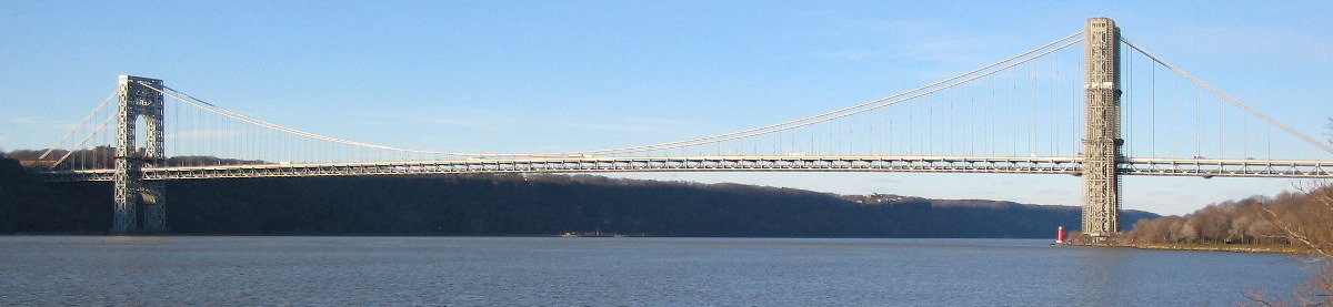
shore and check out the Little Red Lighthouse — we're at the end of
this section, so you deserve a little break. On the plaque you'll see
how this structure was saved from demolition. Incidentally, it was at
one time one of only two working lighthouses in the borough of
Manhattan. Do you know where the other one is? (I'll bet you've seen
it.)
Slideshow: More Riverside Park up to the GWB (and the Little Red Lighthouse)
The Little Red Light House to Dyckman
Street (about 1.2 miles) Three Ways to Go: Now you have to choose
—
There are three ways to do this
section and they're all nice. Since you may be going all the way up
and back again, you can take a different route on the way back, but
you still have to choose. I call them The "High Road",
the "Middle Road", and the "Low Road".
The distances vary slightly with the High Road being the longest and
the Low road the shortest, but if you go up on one and back on
another it will all average out. Take a good look at the map and then I'll go into some details:
The High Road - via The Cloisters
I think this is the nicest - it
has the very best views and a nice climb to get up to the top of the
hill. It goes by the highest point in Manhattan. I think it would be
good choice for the outbound part of the run.
Go over the pedestrian bridge
From the Little Red Lighthouse, head up the paved walkway which
goes under the bridge and slightly to the right. Circle around and go
through the underpass which goes under the south-bound lanes of the
parkway. Continue steeply around to the left and you will shortly
(and breathlessly) reach the promenade. There will be traffic right
in front of you and the bridge abutment just to the right. Go left
onto the promenade and you'll soon see the pedestrian bridge which
crosses the highway
Cross the bridge and cross the street to the sidewalk on the other
side, and head up to the right. You will soon reach 181st Street.
Head left (east) on 181st for 3 blocks to Pinehurst Avenue. Go left
up the stairs. "Huh! the stairs?" Yes, it's too steep for
cars, so there are stairs, sorry (you can walk if you don't feel like
running). Note that if you go one more block instead of going up the
stairs, there's subway access and the GWB bus terminal is two blocks
to the right for bathrooms and supplies.
I prefer Pinehurst Avenue to get to the Cloisters. Most folks
would go a block further and go left at Fort Washington, but I find
that much busier with traffic and parked cars.
At the top of the stairs, go straight north on Pinehurst for about
3 blocks where you'll see Bennett Park on the right. Go in and check
out the rock formation just inside the fence about halfway along the
length of the park. You are looking at the highest point in
Manhattan. There's an old stone marker next to the rock giving the
elevation of 165.03 feet above sea level.
Back on Pinehurst Avenue, continue north to 187th Street where it
merges with Cabrini Blvd. Continue north, now on Cabrini and you will
soon get to the southern part of Fort Tryon Park with a steep
drop-off on the left with nice views of the Hudson and Palisades.
Keep on Cabrini, which curves to the right and you'll soon come to
the main entrance to Fort Tryon Park. Across to the right is the
190th Street A Train subway entrance. The trains actually run
far below and you'll take an elevator down if you need to get a
train.
Now the nice part - Fort Tryon Park is one of the gems of
Manhattan or of the whole of New York City, for that matter. Go into
the park and head along the sidewalk (not the road) and head for the
flag pole, which is on a promontory surrounded by a stone rampart
with stairs up to the top. This point, nearly as high as Bennett
Park, has the most fantastic views in all of New York City.
Unobstructed 360° views of the GWB, The Palisades, up towards
Westchester, and east over much of the Bronx. If you do this run, you
must climb the steps to this point.
Keep heading north on the various pathways and you'll next see the
Cloisters, a branch of the Metropolitan Museum. It's a treasure trove
of medieval art and architecture. It's worth a trip back when you're
not doing a 20 miler.
Get on the path furthest to the west (towards the river) and
circle around the Cloisters. As you drop below the level of the road,
follow the path down the hill towards the north. Always stay on the
left-most path and zig-zag down the hill. There is a very sharp left
near the street level, and then you'll exit the park onto Riverside
Drive. Cross the street and head down Payson Avenue and you'll come
out onto Dyckman Street with the bathroom in the park across the
street to the left.
Slideshow: The High Road – to Dyckman Steet via The Cloisters
The Middle Road - via the old
Riverside Drive Promenade
This is the "traditional"
way to go. It has good views and uses the little known promenade
along the parkway. This used to be Riverside Drive before the Henry
Hudson Parkway was built and has many old and beautiful structures.
Note: since it is so open, there is very little noise or smell from
the nearby traffic.
From the Little Red Lighthouse,
head up the paved walkway which goes under the bridge and
Approaching the "Grecian Temple"
slightly to
the right. Circle around and go through the underpass which goes
under the south-bound lanes of the parkway. Continue steeply around
to the left and you will shortly (and breathlessly) reach the
promenade. There will be traffic right in front of you and the bridge
abutment just to the right. Go left onto the promenade and you're
good to go.
The upper roadway (northbound lanes) of the Henry Hudson Parkway
is actually the old Riverside Drive, which pre-existed the highway.
Head left (north) on the sidewalk (you will be on the left or west
side of the road), and go around the pedestrian bridge, which you
will shortly come to.
Go past the "Grecian Temple" on the left and the
entrance to the Cloisters and Fort Tryon Park across the road on the
right. Keep on this sidewalk all the way to Dyckman Street – note
the exit sign for the cars. At this point the sidewalk ends and there
is a stairway down to the street below. This stretch along the old
Riverside Drive north of the GWB has marvelous views of the cliff
side, the Hudson River and the Palisades beyond.
At the bottom of the stairs, go left under the highway. The sign
will say Riverside Drive. Turn left immediately on Staff Street (1
block downhill) to Dyckman Street. Cross Dyckman Street to the north
side where there is a bathroom a short distance to the right (east).
Slideshow: The Middle Road – to Dyckman Steet via the Promenade
The Low Road - via the path
next to the tracks along the river
This is the least well
known and seldom traveled by anyone (I may be the only one?
).
It's all on dirt, mostly a dirt road, but initially a path. One
section is a little rough where the path all but disappears and there
is a bit of underbrush and some rocky sections. It's not dangerous,
but if you're squeamish, take another route. But if you're the
adventurous sort and like to "Go where no man (err, I mean no
person) has gone before", it may be the route for you.
The path entrance just before the RR overpass
I had always assumed you couldn't get from the GWB to Dyckman
Street along the river due to a section just north of the bridge
where the path seemed to disappear and it looked like you would need
to go through one of the holes in the railroad fence to get around
that spot. But just this winter, I saw a Parks Department sign at the
Dyckman Street end indicating the path was now controlled by the
Parks Department, not, as I had thought, by the railroad. So I
decided to explore it again to see it there was a connection. There
IS. It's rough, it's narrow and I got burdock stuck to my socks —
but I passed the entire length of the path/road on the safe and legal
side of the fence, all the while staying on my two feet. And this is
no Parks Department path — it is, as we call it, "a herd
path."
I liked this route. It's a very
remote area for Manhattan, and the only way to get to it is from the
ends, and it would be difficult for most folks going by the south end
of the route (just above the GWB) to even notice that there was the
entrance to a path there. If you do it, you'll be in a very small
company.
From the Little Red Lighthouse, head up the paved walkway which
goes under the bridge and slightly to the right. Circle around and
when you get to the overpass over the tracks, stop at the near side
of the bridge. Facing north, you will see a parks department sign and
the fence which goes along the north side of the bridge. Between the
sign and the end of the fence there is a clear opening and a path
leading down the slope (see the picture to the left). This is the
start of the path. If you start the slideshow you'll see the first
hundred yards of it.
Go down the path and keep to the far left. At the bottom of the
slope the path continues on more or less continuously for about 100
yards. Soon the vegetation will end and the path will narrow and get
rocky as it goes along near the fence. Take it easy, go slow and
after about 100 yards of this, the vegetation will start again and
behold, you have made it.
Once you're back on the path, it soon turns into a dirt road and
it's smooth sailing to Dyckman Street. You'll see some of the
structures on the old Riverside Drive Promenade up to the right, and
you will get a nice peek at the tower of The Cloisters just where the
path turns into a road.
Eventually you'll be at Dyckman Street. Except for the rough spot,
this is the shortest and easiest of the three routes with absolutely
no hills besides the one to get up to the overpass of the tracks at
the beginning.
Slideshow: The Low Road – to Dyckman Steet via the shore path
From Dyckman Street around Inwood Hill
Park (about 2 miles)
The bathroom on Dyckman Streert
Head west on Dyckman towards the
Hudson and pass under all the bridges. Immediately you'll see the
entrance to Inwood Hill Park on the right. But if you'd like a
pleasant side trip, go over towards the river and check out the new
fishing pier. If you go out to the end you'll get great views up and
down the river. Having done that, enter Inwood Hill Park and head
north along the bike path and keep to the right of the fenced playing
fields. Soon you'll come to the pedestrian bridge over the track. If
you're lucky you may see an Amtrak Train zoom along under the bridge.
I managed to get a nice photo of such a train on my last visit.
Bear left on the path after crossing the tracks and stay on the
left-most path nearest the river all the way around. This beautifully
wooded area of the park gives you an idea of what Manhattan looked
like in pre-colonial days. The path will rise and you will soon pass
under the Henry Hudson Bridge far above. This is the northern tip of
Manhattan and the halfway point of the run.
Continue on the path and head slightly down hill. You'll see the
big "C" painted on the rocks across the river for the
Columbia Crew Team, which works out here. Soon you come out of the
bridge and see a big rock in the center of the path with a bronze
plaque. Read the inscription. It's a very historic spot in the
history of Manhattan, but I won't tell. You gotta go there to see it,
and don't take the subway - run there.
Cross the open area of the park up towards the right and head for
the flag pole. Then run straight east past the bathroom and you will
exit the park at Seaman Ave. Head right (south) along Seaman past
207th Street to Payson. Go right on Payson and up and over a slight
hill as the street turns to the left and then down a long incline to
Dyckman Street, just east of the restrooms.
Slideshow: Inwood Hill Park – around the tip of Manhattan
Now, sad to say, you have to go back
to Central Park
At this point you must head back,
by whichever of the three routes you prefer, to the Little Red Light
House and thence via Riverside Park and 72nd Street to your starting
point in Central Park.
To get to the "High Road",
cross Dyckman and head up Payson one block, cross Riverside Drive and
enter the path up the hill through Fort Tryon Park. For the "Middle
Road" go right (west) on Dyckman 2 blocks to Staff Street,
and head left up the hill, under the underpass and up the stairs to
the promenade. And for the "Low Road" go right
(west) on Dyckman, under the 3 bridges and go left through the gate
before the river, directly across from where you entered Inwood Hill
Park.


 FaceBook and have since promoted each blog entry on Flyers Facebook in addition to continuing to post an announcement and link for each entry on the Flyers Website Homepage. During a recent month, the "referring sites" that led readers to the blog included 300+ pageviews from Facebook vs. 130 pageviews via the Flyers website. Also, Flyer Leslie L tweets about new entries on Flyers Twitter.




 ).
It's all on dirt, mostly a dirt road, but initially a path. One
section is a little rough where the path all but disappears and there
is a bit of underbrush and some rocky sections. It's not dangerous,
but if you're squeamish, take another route. But if you're the
adventurous sort and like to "Go where no man (err, I mean no
person) has gone before", it may be the route for you.
).
It's all on dirt, mostly a dirt road, but initially a path. One
section is a little rough where the path all but disappears and there
is a bit of underbrush and some rocky sections. It's not dangerous,
but if you're squeamish, take another route. But if you're the
adventurous sort and like to "Go where no man (err, I mean no
person) has gone before", it may be the route for you.
