
The West Side Run
The West Side Run
"The most beautiful route in Manhattan"
by Papa Bear
I did this run on a beautiful, cold, sunny day in January of 2010,
as the sparse foliage on the trees will show.
It was the first "Beyond Central Park" long run
description in the Flyers 2010 newsletter. In adapting the report for
the Flyers Blog, I've
edited some descriptive material and changed some of the pictures. And
note well: study the pictures — they should help make the directions
clearer.
You can see a version of this run on my own web site: Beyond Central Park: The West Side Run.
It's a great run, enjoy,
Papa Bear
You can see a version of this run on my own web site: Beyond Central Park: The West Side Run.
It's a great run, enjoy,
Papa Bear
Once in a while, you may feel you've done just one too many loops of
Central Park. When you're in the middle of one of the long marathon
training
runs with 14,000 other runners, you might yearn for a little peace and
quiet to get into your groove without bumping into the runner next to
you.
Maybe you need to find a new distance. Or have some fun in the snow or
in the woods. Or just go someplace new.
The West Side Run - Up along the Hudson River Shoreline and Back
The Central Park Boathouse to Riverside Park at 72nd Street (about 1.5 mile)
 |
| The meeting place at 72nd Street |
At the end of each section you will see a button to turn on the slideshow for that section. I highly recommend you do this and give the photos a good look. They are not only nice views of the route but they should help you in understanding the direction. So go ahead now and give the button a click:
Riverside Park from 72nd Street to 125th Street (about 3.3 miles)
Enter Riverside Park at 72nd Street and follow the walkway downhill and slightly to the right. Go |
| Under the highway in Riverside Park |
You'll soon come to a split where one path heads up through an underpass on the right and circles left to the center promenade of the park. Running along the promenade, you'll soon pass the attractive Soldier's and Sailor's Monument up on Riverside Drive at 89th Street. Head straight north on this until just before 96th Street (you'll see the exit ramp right in front of you). Then head down the pathway to the left, go under the highway and you'll find yourself back on the river.
Or you can just stay on the riverfront and go over a new section where the path is built over the river for a few hundred yards. This took a good long time to get built, so enjoy it.
Now it's a straight shot all the way to 125th Street. You'll see the Riverside Church and Grant's Tomb up to the right, and eventually the sidewalk narrows and goes down a slight slope and exits the park.
You will now come out into a totally reconstructed area of piers, greenery and pathways. Just a few years ago this was an ugly parking lot. It's nice to see that progress does sometimes take place. On the right is 125th Street, and ahead and across the street is the Fairway Market.
Riverside and Fort Washington Parks from 125th Street to the Little Red Light House (about 3 miles)
 |
| Around Riverbank State Park (above) |
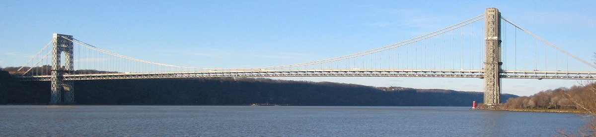
Follow the bike path north all the way to the George Washington Bridge. The park changes its name to Fort Washington Park at around 158th Street. Keep to the right when you get to the tennis courts (it's easy to miss this turn). At the GWB, go to the left at the shore and check out the Little Red Lighthouse — we're at the end of this section, so you deserve a little break. On the plaque you'll see how this structure was saved from demolition. Incidentally, it was at one time one of only two working lighthouses in the borough of Manhattan. Do you know where the other one is? (I'll bet you've seen it.)
The Little Red Light House to Dyckman
Street (about 1.2 miles)
Three Ways to Go: Now you have to choose
—
There are three ways to do this
section and they're all nice. Since you may be going all the way up
and back again, you can take a different route on the way back, but
you still have to choose. I call them The "High Road",
the "Middle Road", and the "Low Road".
The distances vary slightly with the High Road being the longest and
the Low road the shortest, but if you go up on one and back on
another it will all average out. Take a good look at the map and then I'll go into some details:The High Road - via The Cloisters
I think this is the nicest - it has the very best views and a nice climb to get up to the top of the hill. It goes by the highest point in Manhattan. I think it would be good choice for the outbound part of the run.
 |
| Go over the pedestrian bridge |
Cross the bridge and cross the street to the sidewalk on the other side, and head up to the right. You will soon reach 181st Street. Head left (east) on 181st for 3 blocks to Pinehurst Avenue. Go left up the stairs. "Huh! the stairs?" Yes, it's too steep for cars, so there are stairs, sorry (you can walk if you don't feel like running). Note that if you go one more block instead of going up the stairs, there's subway access and the GWB bus terminal is two blocks to the right for bathrooms and supplies.
I prefer Pinehurst Avenue to get to the Cloisters. Most folks would go a block further and go left at Fort Washington, but I find that much busier with traffic and parked cars.
At the top of the stairs, go straight north on Pinehurst for about 3 blocks where you'll see Bennett Park on the right. Go in and check out the rock formation just inside the fence about halfway along the length of the park. You are looking at the highest point in Manhattan. There's an old stone marker next to the rock giving the elevation of 165.03 feet above sea level.
Back on Pinehurst Avenue, continue north to 187th Street where it merges with Cabrini Blvd. Continue north, now on Cabrini and you will soon get to the southern part of Fort Tryon Park with a steep drop-off on the left with nice views of the Hudson and Palisades. Keep on Cabrini, which curves to the right and you'll soon come to the main entrance to Fort Tryon Park. Across to the right is the 190th Street A Train subway entrance. The trains actually run far below and you'll take an elevator down if you need to get a train.
Now the nice part - Fort Tryon Park is one of the gems of Manhattan or of the whole of New York City, for that matter. Go into the park and head along the sidewalk (not the road) and head for the flag pole, which is on a promontory surrounded by a stone rampart with stairs up to the top. This point, nearly as high as Bennett Park, has the most fantastic views in all of New York City. Unobstructed 360° views of the GWB, The Palisades, up towards Westchester, and east over much of the Bronx. If you do this run, you must climb the steps to this point.
Keep heading north on the various pathways and you'll next see the Cloisters, a branch of the Metropolitan Museum. It's a treasure trove of medieval art and architecture. It's worth a trip back when you're not doing a 20 miler.
Get on the path furthest to the west (towards the river) and circle around the Cloisters. As you drop below the level of the road, follow the path down the hill towards the north. Always stay on the left-most path and zig-zag down the hill. There is a very sharp left near the street level, and then you'll exit the park onto Riverside Drive. Cross the street and head down Payson Avenue and you'll come out onto Dyckman Street with the bathroom in the park across the street to the left.
The Middle Road - via the old Riverside Drive Promenade
 |
| Approaching the "Grecian Temple" |
The upper roadway (northbound lanes) of the Henry Hudson Parkway is actually the old Riverside Drive, which pre-existed the highway. Head left (north) on the sidewalk (you will be on the left or west side of the road), and go around the pedestrian bridge, which you will shortly come to.
Go past the "Grecian Temple" on the left and the entrance to the Cloisters and Fort Tryon Park across the road on the right. Keep on this sidewalk all the way to Dyckman Street – note the exit sign for the cars. At this point the sidewalk ends and there is a stairway down to the street below. This stretch along the old Riverside Drive north of the GWB has marvelous views of the cliff side, the Hudson River and the Palisades beyond.
At the bottom of the stairs, go left under the highway. The sign will say Riverside Drive. Turn left immediately on Staff Street (1 block downhill) to Dyckman Street. Cross Dyckman Street to the north side where there is a bathroom a short distance to the right (east).
The Low Road - via the path next to the tracks along the river
 ).
It's all on dirt, mostly a dirt road, but initially a path. One
section is a little rough where the path all but disappears and there
is a bit of underbrush and some rocky sections. It's not dangerous,
but if you're squeamish, take another route. But if you're the
adventurous sort and like to "Go where no man (err, I mean no
person) has gone before", it may be the route for you.
).
It's all on dirt, mostly a dirt road, but initially a path. One
section is a little rough where the path all but disappears and there
is a bit of underbrush and some rocky sections. It's not dangerous,
but if you're squeamish, take another route. But if you're the
adventurous sort and like to "Go where no man (err, I mean no
person) has gone before", it may be the route for you. |
| The path entrance just before the RR overpass |
I liked this route. It's a very remote area for Manhattan, and the only way to get to it is from the ends, and it would be difficult for most folks going by the south end of the route (just above the GWB) to even notice that there was the entrance to a path there. If you do it, you'll be in a very small company.
From the Little Red Lighthouse, head up the paved walkway which goes under the bridge and slightly to the right. Circle around and when you get to the overpass over the tracks, stop at the near side of the bridge. Facing north, you will see a parks department sign and the fence which goes along the north side of the bridge. Between the sign and the end of the fence there is a clear opening and a path leading down the slope (see the picture to the left). This is the start of the path. If you start the slideshow you'll see the first hundred yards of it.
Go down the path and keep to the far left. At the bottom of the slope the path continues on more or less continuously for about 100 yards. Soon the vegetation will end and the path will narrow and get rocky as it goes along near the fence. Take it easy, go slow and after about 100 yards of this, the vegetation will start again and behold, you have made it.
Once you're back on the path, it soon turns into a dirt road and it's smooth sailing to Dyckman Street. You'll see some of the structures on the old Riverside Drive Promenade up to the right, and you will get a nice peek at the tower of The Cloisters just where the path turns into a road.
Eventually you'll be at Dyckman Street. Except for the rough spot, this is the shortest and easiest of the three routes with absolutely no hills besides the one to get up to the overpass of the tracks at the beginning.
From Dyckman Street around Inwood Hill Park (about 2 miles)
 |
| The bathroom on Dyckman Streert |
Bear left on the path after crossing the tracks and stay on the left-most path nearest the river all the way around. This beautifully wooded area of the park gives you an idea of what Manhattan looked like in pre-colonial days. The path will rise and you will soon pass under the Henry Hudson Bridge far above. This is the northern tip of Manhattan and the halfway point of the run.
Continue on the path and head slightly down hill. You'll see the big "C" painted on the rocks across the river for the Columbia Crew Team, which works out here. Soon you come out of the bridge and see a big rock in the center of the path with a bronze plaque. Read the inscription. It's a very historic spot in the history of Manhattan, but I won't tell. You gotta go there to see it, and don't take the subway - run there.
Cross the open area of the park up towards the right and head for the flag pole. Then run straight east past the bathroom and you will exit the park at Seaman Ave. Head right (south) along Seaman past 207th Street to Payson. Go right on Payson and up and over a slight hill as the street turns to the left and then down a long incline to Dyckman Street, just east of the restrooms.
Now, sad to say, you have to go back to Central Park
To get to the "High Road", cross Dyckman and head up Payson one block, cross Riverside Drive and enter the path up the hill through Fort Tryon Park. For the "Middle Road" go right (west) on Dyckman 2 blocks to Staff Street, and head left up the hill, under the underpass and up the stairs to the promenade. And for the "Low Road" go right (west) on Dyckman, under the 3 bridges and go left through the gate before the river, directly across from where you entered Inwood Hill Park.


0 comments:
Post a Comment