
The Bronx is Up, Manhattan is Down —
2 miles too far, 10 degrees too hot, and about an hour too long!
Note: I ran this run
in April, about a month before my marathon (see this),
and as you can see I had really had enough of long runs! The account has been adapted from an
account on my web site, which you are welcome to read: The Bronx is
Up, Manhattan is Down
|
April 21st — My Last 20 Miler (Holy Cow, it was 22.1 miles!)
| H |
ooray! This was my last 20 miler. Of course there is that little matter of a 26 miler coming up, but those are always a lot of fun
 . But there were a couple
of unanticipated things: it got hot — no, not summer hot, but late spring hot —
and I figured my mileage wrong and ended up running over 22 miles. I didn't
actually figure it wrong, but I did some extra side trips which added up, and
took a different route back from Van Cortlandt Park to avoid the long unshaded
route along the Harlem River I had originally planned. But it's done, I feel
fine (I'm writing this on Sunday) and what do they say, "No pain, no gain," whatever.
. But there were a couple
of unanticipated things: it got hot — no, not summer hot, but late spring hot —
and I figured my mileage wrong and ended up running over 22 miles. I didn't
actually figure it wrong, but I did some extra side trips which added up, and
took a different route back from Van Cortlandt Park to avoid the long unshaded
route along the Harlem River I had originally planned. But it's done, I feel
fine (I'm writing this on Sunday) and what do they say, "No pain, no gain," whatever.
Flyers Susan S and Melissa C both joined me but decided to take a different route back and
they ended up with around 16 miles. We all felt the effects of the warmer
weather but I would say everyone was satisfied that it was a good run. Just below are a couple of maps, one for the northbound
and one for the south bound section. They
were generated by the USA Track and Field route tracking software. If
you click on the links under each map you will get the live Google Map from the
USA Track and Field web site. This will also give an elevation profile of the
route.
If you are interested in these routes, email me using the
link at the bottom of the page and I'll give you all the details you want. If
you decide to do this run, I strongly suggest you click on the links for the
USATF interactive maps and zoom in, since some of the fine details of the route
are not given in this report (such as "zig-zagging over to the Grand
Concourse").
There are two small albums on the net, one for the northbound route and
one for the southbound. Just click on the link under the photos for those
sections. When the album comes up, click on the “Slideshow” link on the upper
left of the page.
First Half: Going North, Mostly in the Bronx
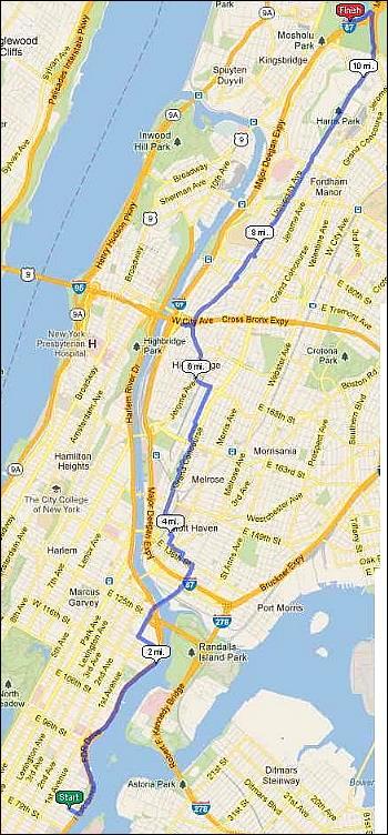
The route was a combination of various other routes we had
done with a few new pieces thrown in. Going up, we started up the East River,
crossed over the Willis Avenue Bridge and did our South Bronx Route. This
involves zig-zagging over to the Grand Concourse and running up through Franz
Sigel Park and Joyce Kilmer Park . At this point we broke some new ground and
made our way up to the Bronx section of the Old Croton Aqueduct (aka the OCA),
via the Edward Grant Highway and University Avenue. Then we retraced the route
we had taken 2 weeks ago along the OCA (see the April
7th MiniBlog post) up to and into Van Cortlandt Park to the Golf Club
House. The part of this on the streets was a bit gritty, but hey, this is the
South Bronx.
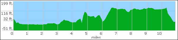
Elevation Profile, Northbound
|
The elevation profile is interesting in that you can spot
the relatively flat and elevated portion when we were running along the
Aqueduct (roughly miles 6.5 to 10.5. That dip just before mile 8 is where the
Aqueduct is interrupted at Burnside Avenue. See this
and this
for that story. It's also interesting to see how you go down when you enter Van Cortlandt Park (the last half mile or so),
That makes sense since if you've run on the OCA in that park, you know it's up
on the side of a hill. The fact that the Aqueduct is at a higher elevation than
just about anything else in the South Bronx shows how expertly the surveyors
laid out the route in the 1830s. Remember, the water was entirely gravity fed
in that era.


Along the OCA in the Bronx
|
One thing that was very noticeable to us was that the
trees were much more in leaf than they were just two weeks before. Take a look
at the above photo and compare it with
some of the scenes looking along the Aqueduct in the April
7th MiniBlog post (especially the one showing the the playgound at Tremont
Avenue and the next one showing the locked gate, which show the same section of
the Aqueduct, although from a different view), you'll see the difference.
Taking a Break in Van Cortlandt Park
We took a break at the Golf Club House in VC Park and after some discussion, the women decided to do around 3 miles on the cross country trails and then head back along the #4 line. Then they would hop on the train when they got the mileage they were looking for. For my part, I would head out to Broadway, fill up on Gatorade from a local deli, and then figure how to get the least exposure to the sun on my way back to Central Park.
Second Half: Going South, Mostly in Manhattan
Taking a Break in Van Cortlandt Park
We took a break at the Golf Club House in VC Park and after some discussion, the women decided to do around 3 miles on the cross country trails and then head back along the #4 line. Then they would hop on the train when they got the mileage they were looking for. For my part, I would head out to Broadway, fill up on Gatorade from a local deli, and then figure how to get the least exposure to the sun on my way back to Central Park.
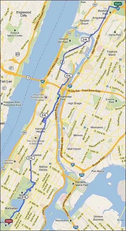
I had taken my shirt off
when we got to Van Cortlandt Park and when I got back to Broadway I put it on
briefly when I went into a deli to get some Gatorade. I ended up carrying the
bottle about 2 miles. Meanwhile my shirt was hot a sticky so I took it off
again. I was amused by the 3 or 4 comments I got, exclusively from young males.
One memorable one was "Put your shirt back on, you're scaring the
women". Hmmm .. Some how I doubt that. I crossed into Manhattan and stayed
on the shady side of Broadway (the east side) till 190th Street. There I took a
little known shortcut: there is a subway entrance for the 190th Street stop on
the #1 train, even though that train runs under St. Nicholoas Avenue at this
point. Well, there is a long horizontal tunnel that heads east under the steep
escarpment, and at the end, an elevator that brings you up the 120 odd feet.
It's shown as a dotted line on the Google map. A great saver for a hot tired
runner. It also explains the unusually steep climb on the elevation profile
(below) around mile 3.5.
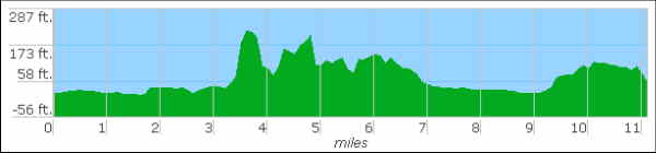
Elevation Profile, Southbound
|
Once I was on the top of the hill at St. Nicholas Avenue, I
ran the two blocks to High Bridge Park and ran down on the park road and the
OCA the length of the park. The very steep down hill, just before mile 5 on the
profile, is the stairway down from the tower to the Aqueduct. Each part of this
route was chosen to minimize exposure to the sun. This route through High
Bridge Park is almost the same (in reverse) to that taken many times, the
latest on my "Manhattan
Parks 20 Miler" which you can read about via the link.

Once past this diversion, you can see the long lazy down
slope along St. Nicholas Avenue from about mile 7 right into Central Park on
the profile. I was sure glad there were no hills at this point in my run.
2 miles too far, 10 degrees too hot, and about an hour too long!
Well, Central Park was a welcome sight and I went down around the Meer and through the Conservatory Garden and finally ended up at the Boat House — 2 miles too far, 10 degrees too hot, and about an hour too long.
2 miles too far, 10 degrees too hot, and about an hour too long!
Well, Central Park was a welcome sight and I went down around the Meer and through the Conservatory Garden and finally ended up at the Boat House — 2 miles too far, 10 degrees too hot, and about an hour too long.
I met Melissa for brunch, got home and crashed. But you
know what? No more 20s! Yes, life is good.
- Papa Bear
(Richard G.)
This account and a number of others featuring long
training runs in the greater New York area primarily lying outsider of
central Park can be found on Papa Bear's web site: Beyond Central Park
|


0 comments:
Post a Comment