
To the Tip of Manhattan: 14 - 20 Miles
Mix and Match Miles to
Brunch
What's It all About
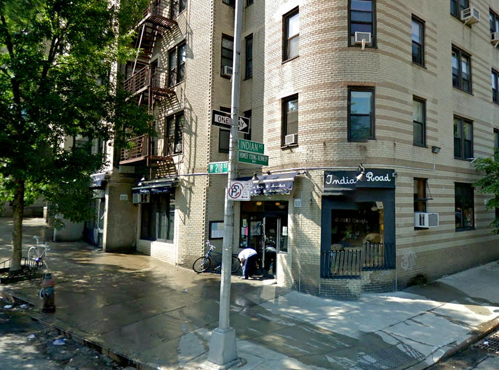 |
| Indian Road Cafe |
And because this was not a purely intellectual exercise, I
actually ran a variation of the ultimate route twice: early in December I ran a
14 miler, mostly through parks (see THIS)
and late in the month I ran a 20 miler with a big stretch on city streets (see THIS).
In both runs I did 3 portions: 1) ran up to Central Park; 2) ran around the park
by a variable amount, and 3) ran from the park up to the northern tip of
Manhattan. The variability comes from how much you do in the park. If you just
pass through the park, you end up with 14 miles. If, in addition, you do a
whole park loop, you end up with 20 miles. And you can obviously do something
in between.
Here's the outline of what I did with a few more details
(mileage is approximate):
·
Run up along the East River, and over to Central
Park (5 miles).
·
Run straight through to the north end of the
park or add up to a 6 mile loop in the park, depending on the mileage you want:
straight through gets you 14 miles total; adding one 6 mile loop gets you 20.
·
Run from the north end of the park and up to
Fort Tryon Park, either along streets (St. Nicholas Avenue, Broadway and Fort
Washington Avenue) or through a series of parks (Morningside, St. Nicholas,
Jackie Robinson and High Bridge), and finish up by running through Fort Tryon
Park (home of the Cloisters) and Inwood Hill Park — or take a short cut along
the east side of Inwood Hill Park. (streets: 7 miles, parks 7¼ miles).
I started on East 20th Street where I live and I entered Central Park at the Engineers' Gate. If you live somewhere else (as I expect you
do), just figure the distance to the Engineers' Gate from where you live and
adjust accordingly. For example, if you live on 72nd and Riverside Drive, it's
2 miles to the Engineers' Gate so add 3 miles somewhere along the way (e,g. add
2 Reservoirs, or run up to the Sailors and Soldiers Monument and back).
So I'll assume you can get to Central Park, and do what
ever loops or side trips it takes to get to the north end of the park. Then you
have 7 miles to go and you will probably be covering new ground. Here are some
maps:
Central Park to the Tip Central Park to the Tip
Via Streets Via Parks


Click for USATF Map Click for USATF Map
Parks vs. Streets? Sounds like a No-brainer.
Central Park to the Tip Central Park to the Tip
Via Streets Via Parks


Click for USATF Map Click for USATF Map
Parks vs. Streets? Sounds like a No-brainer.
Normally, if
you asked me if I would prefer to run from point A to point B by traversing a
series of parks versus running between the same two points along some city
streets, I would say, "Are you kidding? Parks, of course!"
But wait: look at the two maps: the streets route (the map
on the left) is shorter by about a mile and has one gradual climb all the
way to Fort Tryon Park. Not only is the parks route longer — although we make
up the difference — but there are numerous ups and downs. It's clearly more
tiring. I have done both routes and although the parks route is my normal
preference, when I did my 20 miler in late December, I took to the streets
route (map on the right). Bottom line: do what you want, they're both nice
routes, especially on a Saturday morning when there is little street traffic.
The Streets
From the north end of Central Park, at the Lenox Avenue (aka Malcolm X Boulevard) exit, get onto St. Nicholas Avenue. This starts across from the park and goes diagonally up to the left of Lenox. This is long avenue which, under a couple of names, goes all the way up to the north end of Manhattan. It's actually the old "Kings Bridge Road". At 168th Streets you merge into Broadway and follow that to the GWB bus terminal (178th Street). Then you leave the Kings Bridge Road and zig one block left (to the west) to Fort Washington Avenue. For this zig, we usually cut through the bus terminal for a pit stop. Now follow Fort Washington to it's end and you will be at the entrance to Fort Tryon Park.
The map to the left (see the two maps, above) shows it all (click here to bring up the on-line Google Map version), but a few details are worth mentioning: there was little street traffic, a big plus since I don't usually like to run so many miles on city streets; once out of the park, the route is almost all up hill till we got to the cloisters; and lastly, it helped greatly to have such nice running companions — sorry, you'll have to supply those yourself.
The map to the left (see the two maps, above) shows it all (click here to bring up the on-line Google Map version), but a few details are worth mentioning: there was little street traffic, a big plus since I don't usually like to run so many miles on city streets; once out of the park, the route is almost all up hill till we got to the cloisters; and lastly, it helped greatly to have such nice running companions — sorry, you'll have to supply those yourself.
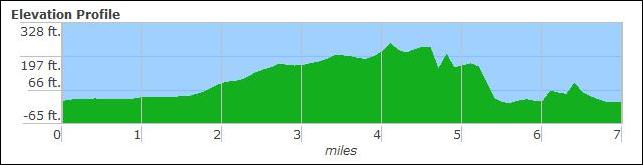 |
| Elevation Profile: Streets Route |
The elevation profile is instructive: it really is one
long hill, but it's never too steep. Good for you training to. Incidentally,
those two bumps from around mile 4 to mile 4½ are the co-highpoints of
Manhattan. If you're interested in high points, read THIS).
And careful examination of the map will show we actually ran THROUGH the GWB bus
station, A good place for a pit stop (plus I cheated and took the escalator!  ).
).
).
The Escarpment Parks
The route
through the parks can be seen on the map at the right (see the two maps, above). Although I mentioned
it's about a mile longer, I actually took a short cut along the east side of
Inwood Hill Park (the northernmost park), so that on that day the difference
was only around ¼ mile. One thing the elevation profile clearly shows is how
upsy and downsy this route is compared with the streets route. Your muscles
will know the difference — both on the day you run and the next morning!
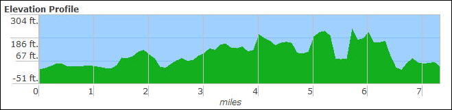 |
| Elevation Profile: Parks Route |
).
Simply put, head up through Central Park, down through the Conservatory Garden and around the
Lake and out the northwest entrance. From there head west on 110th Street a
block and head up through Morningside
Park to the north end at 123rd Street and Morningside Avenue. Then head up
Morningside Avenue for four blocks to 127th and hang a right and then a left on St.
Nicholas Terrace where you will arrive at the south end of St. Nicholas Park. The bathroom is a few blocks north in a
playground. Head all the way up through St. Nicholas staying on the westernmost
path (along the top of the hill). Finally at the north end, go down the stairs
and exit at 141st Street and St. Nicholas Ave. It wouldn't hurt to look at the
map to follow this description (use the on-line map and zoom in).
Now head down (east) on 141st St. one block to Edgecombe.
If you zoom in on the map you'll see I missed Edgecombe. No big deal — in any
case head up to 145th Street and you'll get to Jackie Robinson Park. Make sure you're at the entrance at the top
of the hill, not the bottom (like I was). The simplest way to traverse this
park is just to stay on Edgecombe along the west side of the park all the way
to 155th Street. I actually went down into the park about half way up and
followed an old abandoned path. At 155th Street, head left up the hill and make
sure you go past the road heading down the hill to the Harlem River Drive, and cross
155th St. to the Jackie Robinson Park. You should be on Edgecombe (again) heading north up a
hill, with a triangular park on the other side and housing beyond. This is High Bridge Park, my favorite.
I like to head through this park on the Old Croton
Aqueduct (aka the OCA), starting at 158th Street, or you could also just stay
on Edgecombe, but I strongly recommend the OCA. When you finally get to the end
point of the OCA at the Manhattan end of High Bridge (yes, there is an actual
bridge, unfortunately fenced off), head up the stairs, check out the tower, and
get onto Amsterdam Avenue (yes, Amsterdam, the longest Avenue on the Manhattan
street grid, extends all the way up here). Go up Amsterdam, cross all the
highways and finally take a right on Laurel Hill Terrace. At this point I
normally go down into the park and follow the park roads another half mile
north, but this time I stayed on Laurel Hill.
When I finally got back to Amsterdam, I took a short cut. Instead of following the park all the way up, being cold and hungry, I crossed over on 190th Street and headed west. Then I took two "secret" underground shortcuts: The subway elevator & tunnel at the 191st St. #1 Train station (west side of St. Nicholas just north of and 190th) and the tunnel & elevator at the 190th St. A Train station (west side of Bennet Avenue north of 192nd St). Check the map carefully if you go this way. The later tunnel (the Bennet Avenue A-train station) takes you to an elevator which puts you right at the entrance to Fort Tryon Park.
The tunnels are free, safe, well lighted, have lots of traffic, and they save you some very steep ups and downhills. Don't believe that? Just check the elevation profile above and look at that steep sided valley at mile 5½. That's where you would have to run down from High Bridge Tower to Broadway and then up again to get to Fort Tryon Park. In fact you couldn't possibly run up to that park even if you wanted to — it's a sheer rocky cliff, see this! And it's very cool to traverse these old pieces of New York City infrastructure, all but unknown outside this neighborhood. Besides, how many long runs have you done which include two tunnels and two elevators? And according to the long run gods, these tunnels/elevators count!
The Final Stretch
When I finally got back to Amsterdam, I took a short cut. Instead of following the park all the way up, being cold and hungry, I crossed over on 190th Street and headed west. Then I took two "secret" underground shortcuts: The subway elevator & tunnel at the 191st St. #1 Train station (west side of St. Nicholas just north of and 190th) and the tunnel & elevator at the 190th St. A Train station (west side of Bennet Avenue north of 192nd St). Check the map carefully if you go this way. The later tunnel (the Bennet Avenue A-train station) takes you to an elevator which puts you right at the entrance to Fort Tryon Park.
The tunnels are free, safe, well lighted, have lots of traffic, and they save you some very steep ups and downhills. Don't believe that? Just check the elevation profile above and look at that steep sided valley at mile 5½. That's where you would have to run down from High Bridge Tower to Broadway and then up again to get to Fort Tryon Park. In fact you couldn't possibly run up to that park even if you wanted to — it's a sheer rocky cliff, see this! And it's very cool to traverse these old pieces of New York City infrastructure, all but unknown outside this neighborhood. Besides, how many long runs have you done which include two tunnels and two elevators? And according to the long run gods, these tunnels/elevators count!
The Final Stretch
Fear not, you are in the final stretch. When you get to
the entrance to Fort Tryon Park. Go
north through the park staying on the westernmost path and circle around the
Cloisters and take the steep winding path down to Riverside Drive and then down
another block to Dyckman Street.
Cross Dyckman and for the short cut (paired with the parks route) follow Payson, Seaman,
214th St. and Indian Road — skirting around the eastern edge of Inwood Hill Park (see map) — to the Indian Road Café, our destination.
For the long route (paired with the streets route) go west
on Dyckman all the way to the Hudson River and enter Inwood Hill Park after going under the three bridges. Follow the
path north on the right of the playing fields till you get to the pedestrian
bridge. Cross over the tracks and follow the walkway all the way around under
the Henry Hudson Bridge. Stay to the left at every fork. When you come out of
the woods, pass the memorial rock ("Shorakkopoch Rock", where Peter
Minuet stole purchased Manhattan from the Indians — see THIS) and head
around and to the left all the way out to the street. Cross the street and
you're there.
Indian Road Café
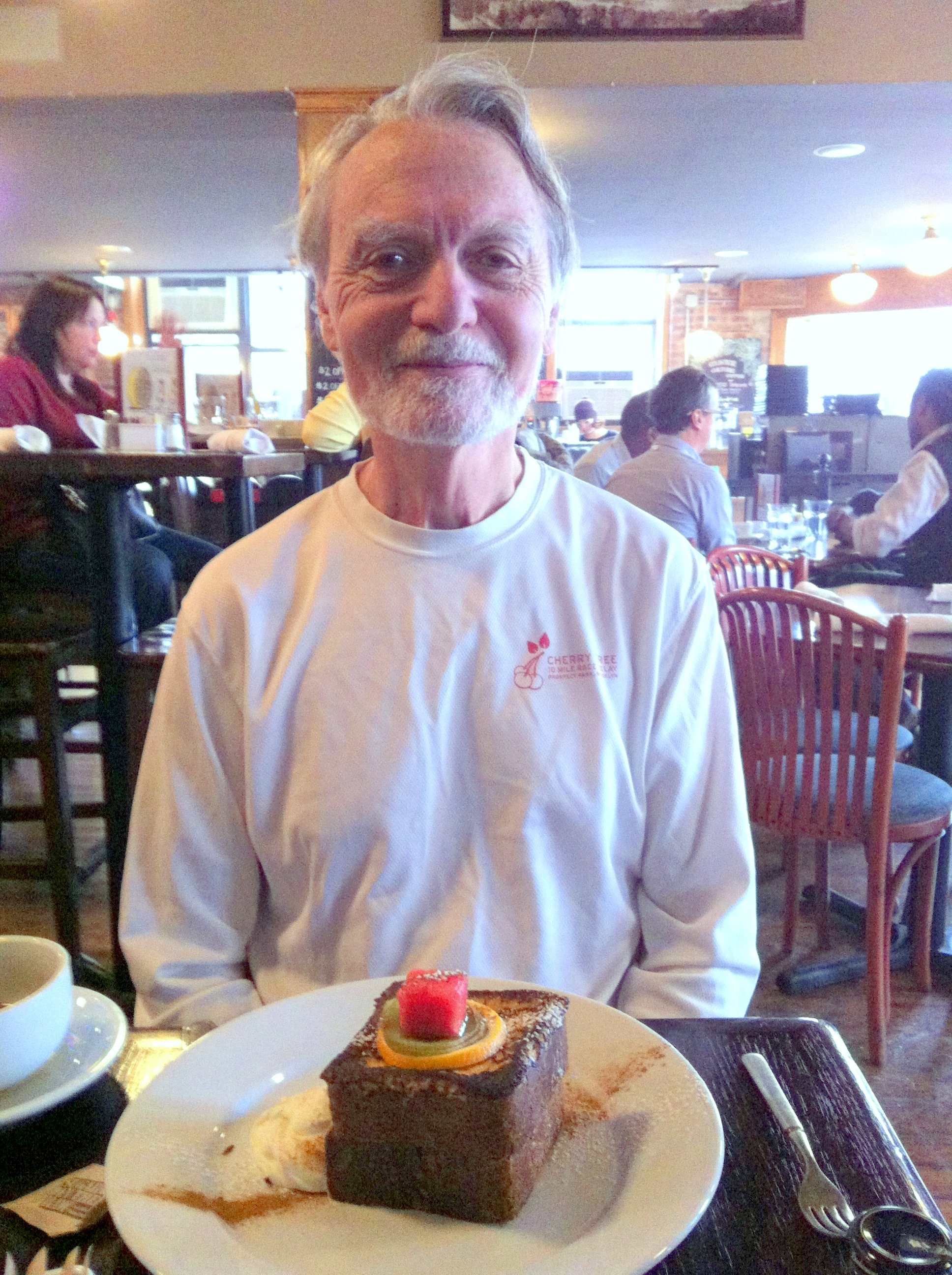 |
| At the Cafe: One Happy Camper |
Perfect Snow — Almost
The day before
the 20 miler, I read this blog on the NY Times web site: Tomorrow,
It Will Snow, Perfectly, a lovely and clever essay on what makes a
"perfect" snow storm in the city: enough snow but not too much, cold
but not too cold, etc. In the blogger's words, "blankets the landscape without burying it, beautifies but does not
burden, transforms and cocoons without paralyzing or even particularly
inconveniencing". Well, when we left the Café and walked the several
blocks to the subway, the falling snow seemed just that. It gave that quiet
sense that new snow gives. Then down into the subway we went to wind our way
home. About 45 minutes later I climbed the stairs out of the subway in my home
neighborhood. Oops ... cold rain and sleet! The spell had been broken. No
longer the perfect snow, but just another yucky winter day in the city.
Oh well, at least we finished our run and finished our
brunch before reality intruded. Happy New Year and Happy Running everyone!
- Papa Bear (Richard G.)


0 comments:
Post a Comment